


Vauvert

Dupuybadonniere
User
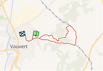

Length
6.7 km

Max alt
97 m

Uphill gradient
72 m
Km-Effort
7.7 km

Min alt
40 m

Downhill gradient
79 m
Boucle
No
Creation date :
2020-11-18 13:32:39.745
Updated on :
2020-11-18 15:41:17.451
2h03
Difficulty : Very easy

FREE GPS app for hiking
 SityTrail
IGN / Geographical institutes
SityTrail Plus
The world is yours!
About
Trail Walking of 6.7 km to be discovered at Occitania, Gard, Vauvert. This trail is proposed by Dupuybadonniere.
Positioning
Country:
France
Region :
Occitania
Department/Province :
Gard
Municipality :
Vauvert
Location:
Unknown
Start:(Dec)
Start:(UTM)
603442 ; 4838846 (31T) N.
Comments