Trail Walking Castillon - La tête de Cuore - Photo
© OpenStreetMap contributors
Length
Length
15.9 km
Max alt
Max alt
1178 m
Uphill gradient
Uphill gradient
903 m
Km-Effort
Km-Effort  
28 km
Min alt
Min alt
719 m
Downhill gradient
Downhill gradient
904 m
Boucle
Boucle
Yes
Creation date :
2014-12-10 00:00:00.0
Updated on :
2014-12-10 00:00:00.0

(0 Reviews)

Walking
Walking
5h24
Difficulty : Easy

Scan this QR Code to open this trail in the SityTrail application

FREE GPS app for hiking

Logo SityTrail SityTrail

IGN / Geographical institutes

Download SityTrail from the App Store Download SityTrail from Google Play

Logo SityTrail SityTrail Plus

The world is yours!

Download SityTrail from the App Store Download SityTrail from Google Play Download SityTrail on Huawei AppGallery

About

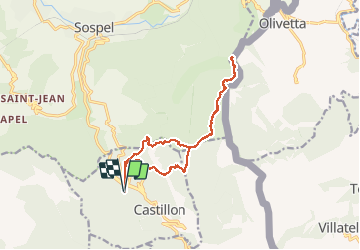
Trail Walking of 15.9 km to be discovered at Provence-Alpes-Côte d'Azur, Maritime Alps, Castillon. This trail is proposed by PEBREJOSIANE.

Description

Le départ s'effectue du parking du vieux Castillon, on franchit successivement la baisse de Scuvion , le col de roulabre, le col du Razet, le col de Cuore, le pas du Cuore et on arrive à La tête du Cuore. Le retour s'effectue par le même itinéraire jusqu'au colde Roulabre.
On se dirige ensuite vers la Pierre pointue et le parking.
Nombreuses bornes frontière.

Elevation profile

Positioning

Country:
France
Region :
Provence-Alpes-Côte d'Azur
Department/Province :
Maritime Alps
Municipality :
Castillon
Location:
Unknown
Start:(UTM)
376235 ; 4854964 (32T) N.


Close
My subscriptions