


circuit des chicons

dehemjacques
User

Length
11.7 km

Max alt
38 m

Uphill gradient
61 m
Km-Effort
12.5 km

Min alt
26 m

Downhill gradient
60 m
Boucle
Yes
Creation date :
2020-11-20 13:46:08.193
Updated on :
2020-11-20 16:51:11.867
2h21
Difficulty : Easy

FREE GPS app for hiking
 SityTrail
IGN / Geographical institutes
SityTrail Plus
The world is yours!
About
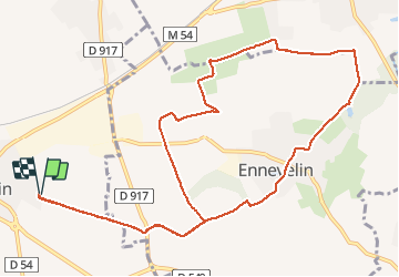
Trail Walking of 11.7 km to be discovered at Hauts-de-France, Nord, Avelin. This trail is proposed by dehemjacques.
Description
avelin, Ennevelin et Fretin
Photos


Positioning
Country:
France
Region :
Hauts-de-France
Department/Province :
Nord
Municipality :
Avelin
Location:
Unknown
Start:(Dec)
Start:(UTM)
506347 ; 5598384 (31U) N.
Comments