


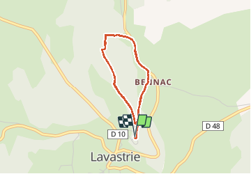
Boucles VTT Bois de Bennac

planets
User

Length
13.2 km

Max alt
1023 m

Uphill gradient
395 m
Km-Effort
18.5 km

Min alt
956 m

Downhill gradient
395 m
Boucle
Yes
Creation date :
2020-11-21 14:42:33.784
Updated on :
2020-11-21 15:36:19.543
52m
Difficulty : Very easy

FREE GPS app for hiking
 SityTrail
IGN / Geographical institutes
SityTrail Plus
The world is yours!
About
Trail Mountain bike of 13.2 km to be discovered at Auvergne-Rhône-Alpes, Cantal, Neuvéglise-sur-Truyère. This trail is proposed by planets.
Positioning
Country:
France
Region :
Auvergne-Rhône-Alpes
Department/Province :
Cantal
Municipality :
Neuvéglise-sur-Truyère
Location:
Unknown
Start:(Dec)
Start:(UTM)
503539 ; 4975970 (31T) N.
Comments