


barsac

raygautier
User
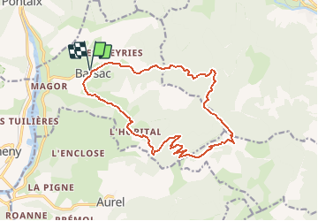

Length
17.2 km

Max alt
1224 m

Uphill gradient
901 m
Km-Effort
29 km

Min alt
372 m

Downhill gradient
901 m
Boucle
Yes
Creation date :
2020-11-22 09:30:41.135
Updated on :
2020-11-22 09:31:28.139
--
Difficulty : Difficult

FREE GPS app for hiking
 SityTrail
IGN / Geographical institutes
SityTrail Plus
The world is yours!
About
Trail On foot of 17.2 km to be discovered at Auvergne-Rhône-Alpes, Drôme, Barsac. This trail is proposed by raygautier.
Description
difficile
Positioning
Country:
France
Region :
Auvergne-Rhône-Alpes
Department/Province :
Drôme
Municipality :
Barsac
Location:
Unknown
Start:(Dec)
Start:(UTM)
681400 ; 4955669 (31T) N.
Comments