


Vauvert

Dupuybadonniere
User
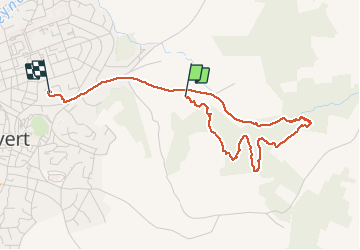

Length
4.2 km

Max alt
86 m

Uphill gradient
72 m
Km-Effort
5.2 km

Min alt
42 m

Downhill gradient
77 m
Boucle
No
Creation date :
2020-11-23 13:35:31.683
Updated on :
2020-11-23 15:06:31.25
1h30
Difficulty : Very easy

FREE GPS app for hiking
 SityTrail
IGN / Geographical institutes
SityTrail Plus
The world is yours!
About
Trail Walking of 4.2 km to be discovered at Occitania, Gard, Vauvert. This trail is proposed by Dupuybadonniere.
Positioning
Country:
France
Region :
Occitania
Department/Province :
Gard
Municipality :
Vauvert
Location:
Unknown
Start:(Dec)
Start:(UTM)
604103 ; 4838814 (31T) N.
Comments