


Vauvert

Dupuybadonniere
User
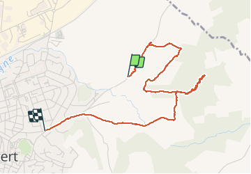

Length
4.4 km

Max alt
73 m

Uphill gradient
52 m
Km-Effort
5.1 km

Min alt
44 m

Downhill gradient
51 m
Boucle
No
Creation date :
2020-11-25 13:33:37.475
Updated on :
2020-11-25 14:57:44.344
1h23
Difficulty : Very easy

FREE GPS app for hiking
 SityTrail
IGN / Geographical institutes
SityTrail Plus
The world is yours!
About
Trail Walking of 4.4 km to be discovered at Occitania, Gard, Vauvert. This trail is proposed by Dupuybadonniere.
Positioning
Country:
France
Region :
Occitania
Department/Province :
Gard
Municipality :
Vauvert
Location:
Unknown
Start:(Dec)
Start:(UTM)
604114 ; 4839313 (31T) N.
Comments