


suc de montasset

raab
User
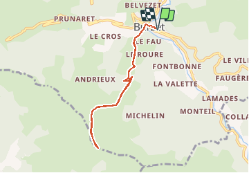

Length
7.3 km

Max alt
1022 m

Uphill gradient
491 m
Km-Effort
13.9 km

Min alt
538 m

Downhill gradient
491 m
Boucle
Yes
Creation date :
2020-11-28 09:30:21.075
Updated on :
2020-11-28 09:31:19.405
--
Difficulty : Easy

FREE GPS app for hiking
 SityTrail
IGN / Geographical institutes
SityTrail Plus
The world is yours!
About
Trail On foot of 7.3 km to be discovered at Auvergne-Rhône-Alpes, Ardèche, Burzet. This trail is proposed by raab.
Positioning
Country:
France
Region :
Auvergne-Rhône-Alpes
Department/Province :
Ardèche
Municipality :
Burzet
Location:
Unknown
Start:(Dec)
Start:(UTM)
598662 ; 4954789 (31T) N.
Comments