


Charande par le col de la croix Perrin

crocau
User
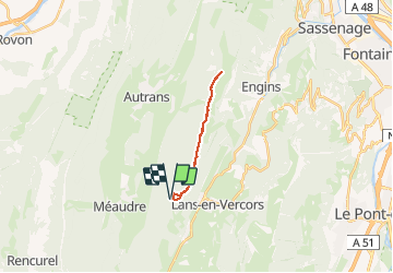

Length
16.3 km

Max alt
1714 m

Uphill gradient
640 m
Km-Effort
25 km

Min alt
1228 m

Downhill gradient
641 m
Boucle
Yes
Creation date :
2020-11-28 12:15:01.208
Updated on :
2020-11-28 19:10:44.308
4h46
Difficulty : Very easy

FREE GPS app for hiking
 SityTrail
IGN / Geographical institutes
SityTrail Plus
The world is yours!
About
Trail Walking of 16.3 km to be discovered at Auvergne-Rhône-Alpes, Isère, Lans-en-Vercors. This trail is proposed by crocau.
Photos


Positioning
Country:
France
Region :
Auvergne-Rhône-Alpes
Department/Province :
Isère
Municipality :
Lans-en-Vercors
Location:
Unknown
Start:(Dec)
Start:(UTM)
701311 ; 5000636 (31T) N.
Comments