


col de l'Arc

CABERMAT
User
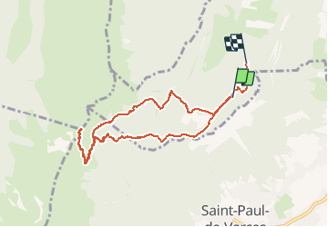

Length
9 km

Max alt
1742 m

Uphill gradient
576 m
Km-Effort
16.9 km

Min alt
1104 m

Downhill gradient
656 m
Boucle
No
Creation date :
2020-11-29 10:27:51.372
Updated on :
2020-11-29 15:27:15.384
2h37
Difficulty : Very easy

FREE GPS app for hiking
 SityTrail
IGN / Geographical institutes
SityTrail Plus
The world is yours!
About
Trail Walking of 9 km to be discovered at Auvergne-Rhône-Alpes, Isère, Varces-Allières-et-Risset. This trail is proposed by CABERMAT.
Positioning
Country:
France
Region :
Auvergne-Rhône-Alpes
Department/Province :
Isère
Municipality :
Varces-Allières-et-Risset
Location:
Unknown
Start:(Dec)
Start:(UTM)
707936 ; 4996114 (31T) N.
Comments