


Banneux -Tancremont 10 KM

Efr
User
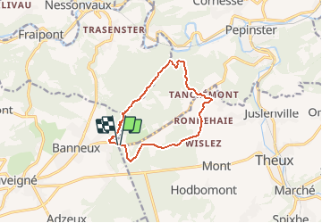

Length
9.5 km

Max alt
333 m

Uphill gradient
246 m
Km-Effort
12.8 km

Min alt
158 m

Downhill gradient
247 m
Boucle
Yes
Creation date :
2020-11-06 21:49:46.773
Updated on :
2020-11-15 17:02:55.581
--
Difficulty : Medium

FREE GPS app for hiking
 SityTrail
IGN / Geographical institutes
SityTrail Plus
The world is yours!
About
Trail On foot of 9.5 km to be discovered at Wallonia, Liège, Pepinster. This trail is proposed by Efr.
Description
Départ Banneux apparition
Positioning
Country:
Belgium
Region :
Wallonia
Department/Province :
Liège
Municipality :
Pepinster
Location:
Pepinster
Start:(Dec)
Start:(UTM)
695095 ; 5602203 (31U) N.
Comments