


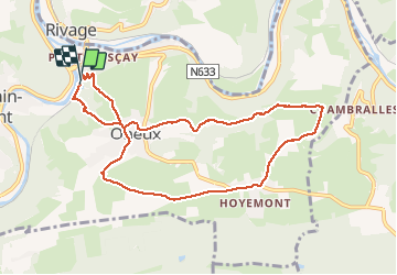
pont de sçay . oneux . chambralles . hoyenon . oneux . pont de sçay

stef789
User GUIDE

Length
8.4 km

Max alt
297 m

Uphill gradient
220 m
Km-Effort
11.4 km

Min alt
100 m

Downhill gradient
217 m
Boucle
Yes
Creation date :
2020-12-02 13:25:48.293
Updated on :
2020-12-02 16:02:20.104
2h15
Difficulty : Very easy

FREE GPS app for hiking
 SityTrail
IGN / Geographical institutes
SityTrail Plus
The world is yours!
About
Trail Walking of 8.4 km to be discovered at Wallonia, Liège, Comblain-au-Pont. This trail is proposed by stef789.
Photos


Positioning
Country:
Belgium
Region :
Wallonia
Department/Province :
Liège
Municipality :
Comblain-au-Pont
Location:
Comblain-au-Pont
Start:(Dec)
Start:(UTM)
683774 ; 5594957 (31U) N.
Comments