


Tombouctou

Nila81
User
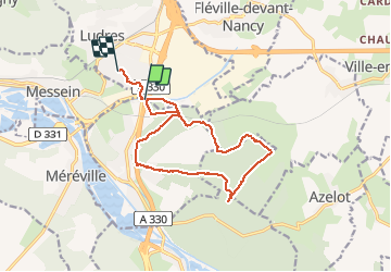

Length
13 km

Max alt
328 m

Uphill gradient
178 m
Km-Effort
15.3 km

Min alt
239 m

Downhill gradient
153 m
Boucle
No
Creation date :
2020-12-03 12:44:31.721
Updated on :
2020-12-03 15:25:15.631
2h39
Difficulty : Very easy

FREE GPS app for hiking
 SityTrail
IGN / Geographical institutes
SityTrail Plus
The world is yours!
About
Trail Walking of 13 km to be discovered at Grand Est, Meurthe-et-Moselle, Richardménil. This trail is proposed by Nila81.
Description
forêt
Positioning
Country:
France
Region :
Grand Est
Department/Province :
Meurthe-et-Moselle
Municipality :
Richardménil
Location:
Unknown
Start:(Dec)
Start:(UTM)
291753 ; 5387767 (32U) N.
Comments