


la coueste de moi

Coryphene
User
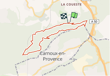

Length
8.7 km

Max alt
382 m

Uphill gradient
287 m
Km-Effort
12.5 km

Min alt
137 m

Downhill gradient
289 m
Boucle
Yes
Creation date :
2020-12-03 15:46:48.273
Updated on :
2020-12-17 17:08:47.294
--
Difficulty : Easy

FREE GPS app for hiking
 SityTrail
IGN / Geographical institutes
SityTrail Plus
The world is yours!
About
Trail On foot of 8.7 km to be discovered at Provence-Alpes-Côte d'Azur, Bouches-du-Rhône, Aubagne. This trail is proposed by Coryphene.
Description
une descente un peu raide
Positioning
Country:
France
Region :
Provence-Alpes-Côte d'Azur
Department/Province :
Bouches-du-Rhône
Municipality :
Aubagne
Location:
Unknown
Start:(Dec)
Start:(UTM)
708980 ; 4794287 (31T) N.
Comments
une belle randonnée