


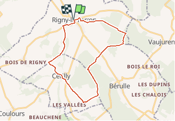
Promenade des Sources - Rigny le Ferron

c.chehere
User


3h45
Difficulty : Difficult

FREE GPS app for hiking
 SityTrail
IGN / Geographical institutes
SityTrail Plus
The world is yours!
About
Trail Walking of 14.8 km to be discovered at Grand Est, Aube, Rigny-le-Ferron. This trail is proposed by c.chehere.
Description
Circuit proposé par l’Office de Tourisme du Pays d’Othe. Départ de la mairie de Rigny le Ferron. Retrouvez ce circuit sur le site de l’Office du Tourisme. Circuit interdit en période de chasse. Ce circuit a été numérisé par les randonneurs du CODEPEM. Merci à Jean-Marie.
Positioning
Comments