


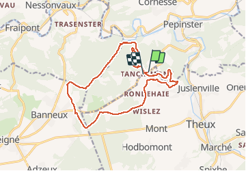
entre tancremont et banneux

stef789
User GUIDE

Length
14.6 km

Max alt
330 m

Uphill gradient
306 m
Km-Effort
18.7 km

Min alt
144 m

Downhill gradient
306 m
Boucle
Yes
Creation date :
2020-12-05 10:59:49.224
Updated on :
2020-12-05 15:47:43.894
4h46
Difficulty : Very easy

FREE GPS app for hiking
 SityTrail
IGN / Geographical institutes
SityTrail Plus
The world is yours!
About
Trail Walking of 14.6 km to be discovered at Wallonia, Liège, Theux. This trail is proposed by stef789.
Photos


Positioning
Country:
Belgium
Region :
Wallonia
Department/Province :
Liège
Municipality :
Theux
Location:
Theux
Start:(Dec)
Start:(UTM)
697363 ; 5603711 (31U) N.
Comments
Très belle boucle boisée et campagnarde.