


Arville 031220

guyernage25
User
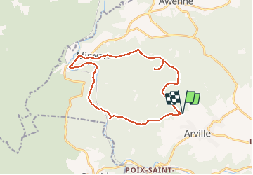

Length
14.3 km

Max alt
487 m

Uphill gradient
340 m
Km-Effort
18.9 km

Min alt
266 m

Downhill gradient
338 m
Boucle
Yes
Creation date :
2020-12-03 08:48:13.765
Updated on :
2020-12-05 16:21:36.037
3h21
Difficulty : Easy

FREE GPS app for hiking
 SityTrail
IGN / Geographical institutes
SityTrail Plus
The world is yours!
About
Trail Walking of 14.3 km to be discovered at Wallonia, Luxembourg, Saint-Hubert. This trail is proposed by guyernage25.
Description
belle rando forestiere par la vallée de la Lomme
Photos


Positioning
Country:
Belgium
Region :
Wallonia
Department/Province :
Luxembourg
Municipality :
Saint-Hubert
Location:
Arville
Start:(Dec)
Start:(UTM)
665363 ; 5545500 (31U) N.
Comments