


Mont Ours depuis col de Castillon

aris
User
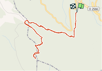

Length
7.3 km

Max alt
1229 m

Uphill gradient
499 m
Km-Effort
14 km

Min alt
737 m

Downhill gradient
498 m
Boucle
Yes
Creation date :
2020-12-06 10:04:28.415
Updated on :
2021-02-13 22:35:16.629
2h25
Difficulty : Easy

FREE GPS app for hiking
 SityTrail
IGN / Geographical institutes
SityTrail Plus
The world is yours!
About
Trail Walking of 7.3 km to be discovered at Provence-Alpes-Côte d'Azur, Maritime Alps, Castillon. This trail is proposed by aris.
Description
Randonnée facile de moins de 3h pour confinement version "3h, 20km". Vue panoramique en haut.
Positioning
Country:
France
Region :
Provence-Alpes-Côte d'Azur
Department/Province :
Maritime Alps
Municipality :
Castillon
Location:
Unknown
Start:(Dec)
Start:(UTM)
376231 ; 4854984 (32T) N.
Comments