Saint Marcel Ile Chaumette 15 km

grasgilbert
User
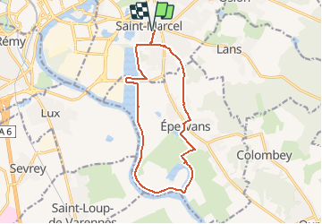

Length
14 km

Max alt
186 m

Uphill gradient
71 m
Km-Effort
15 km

Min alt
168 m

Downhill gradient
71 m
Boucle
Yes
Creation date :
2020-12-06 14:39:21.181
Updated on :
2021-04-24 16:15:54.068
--
Difficulty : Very easy

FREE GPS app for hiking
 SityTrail
IGN / Geographical institutes
SityTrail Plus
The world is yours!
About
Trail On foot of 14 km to be discovered at Bourgogne-Franche-Comté, Saône-et-Loire, Saint-Marcel. This trail is proposed by grasgilbert.
Description
essai
Positioning
Country:
France
Region :
Bourgogne-Franche-Comté
Department/Province :
Saône-et-Loire
Municipality :
Saint-Marcel
Location:
Unknown
Start:(Dec)
Start:(UTM)
644197 ; 5181836 (31T) N.
Comments