


Thury sous clermont

Djaie60
User
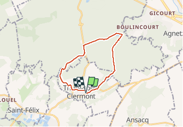

Length
10.6 km

Max alt
162 m

Uphill gradient
182 m
Km-Effort
13 km

Min alt
69 m

Downhill gradient
180 m
Boucle
Yes
Creation date :
2020-12-07 10:48:32.0
Updated on :
2021-01-20 15:34:05.625
--
Difficulty : Very easy

FREE GPS app for hiking
 SityTrail
IGN / Geographical institutes
SityTrail Plus
The world is yours!
About
Trail On foot of 10.6 km to be discovered at Hauts-de-France, Oise, Thury-sous-Clermont. This trail is proposed by Djaie60.
Positioning
Country:
France
Region :
Hauts-de-France
Department/Province :
Oise
Municipality :
Thury-sous-Clermont
Location:
Unknown
Start:(Dec)
Start:(UTM)
450981 ; 5467303 (31U) N.
Comments
Bon parcours attention le terme "Très Facile" n'est pas adapté à tout les niveaux :)