


Précy 10.76km

Djaie60
User
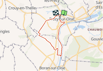

Length
10.8 km

Max alt
112 m

Uphill gradient
111 m
Km-Effort
12.2 km

Min alt
23 m

Downhill gradient
111 m
Boucle
Yes
Creation date :
2020-12-07 13:17:52.0
Updated on :
2021-01-20 15:33:46.492
--
Difficulty : Very easy

FREE GPS app for hiking
 SityTrail
IGN / Geographical institutes
SityTrail Plus
The world is yours!
About
Trail On foot of 10.8 km to be discovered at Hauts-de-France, Oise, Précy-sur-Oise. This trail is proposed by Djaie60.
Positioning
Country:
France
Region :
Hauts-de-France
Department/Province :
Oise
Municipality :
Précy-sur-Oise
Location:
Unknown
Start:(Dec)
Start:(UTM)
453965 ; 5450527 (31U) N.
Comments