


BROC ANOU

Daniel Benteux
User
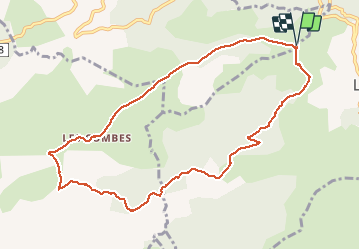

Length
10.8 km

Max alt
1028 m

Uphill gradient
399 m
Km-Effort
16.1 km

Min alt
631 m

Downhill gradient
398 m
Boucle
Yes
Creation date :
2020-12-10 08:24:21.271
Updated on :
2020-12-10 12:13:43.35
3h12
Difficulty : Easy

FREE GPS app for hiking
 SityTrail
IGN / Geographical institutes
SityTrail Plus
The world is yours!
About
Trail Walking of 10.8 km to be discovered at Provence-Alpes-Côte d'Azur, Maritime Alps, Bouyon. This trail is proposed by Daniel Benteux.
Photos


Positioning
Country:
France
Region :
Provence-Alpes-Côte d'Azur
Department/Province :
Maritime Alps
Municipality :
Bouyon
Location:
Unknown
Start:(Dec)
Start:(UTM)
351666 ; 4852903 (32T) N.
Comments