


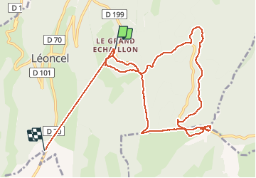
le grand echaillon

raygautier
User

Length
12.9 km

Max alt
1366 m

Uphill gradient
298 m
Km-Effort
17.8 km

Min alt
920 m

Downhill gradient
553 m
Boucle
No
Creation date :
2020-12-10 10:03:44.0
Updated on :
2020-12-11 21:51:56.147
5h05
Difficulty : Unknown

FREE GPS app for hiking
 SityTrail
IGN / Geographical institutes
SityTrail Plus
The world is yours!
About
Trail Walking of 12.9 km to be discovered at Auvergne-Rhône-Alpes, Drôme, Léoncel. This trail is proposed by raygautier.
Positioning
Country:
France
Region :
Auvergne-Rhône-Alpes
Department/Province :
Drôme
Municipality :
Léoncel
Location:
Unknown
Start:(Dec)
Start:(UTM)
674308 ; 4975643 (31T) N.
Comments