


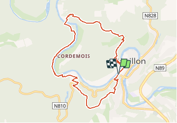
Bouillon Ramonette Epine Belvédère

ramagufa
User

Length
8.8 km

Max alt
369 m

Uphill gradient
359 m
Km-Effort
13.6 km

Min alt
211 m

Downhill gradient
356 m
Boucle
Yes
Creation date :
2020-12-11 20:26:48.952
Updated on :
2020-12-11 20:27:40.41
2h49
Difficulty : Difficult

FREE GPS app for hiking
 SityTrail
IGN / Geographical institutes
SityTrail Plus
The world is yours!
About
Trail Walking of 8.8 km to be discovered at Wallonia, Luxembourg, Bouillon. This trail is proposed by ramagufa.
Positioning
Country:
Belgium
Region :
Wallonia
Department/Province :
Luxembourg
Municipality :
Bouillon
Location:
Bouillon
Start:(Dec)
Start:(UTM)
648494 ; 5517535 (31U) N.
Comments