


Hauts de Champagne. L'Ile-Adam, Champagne sur Oise

philberard95
User
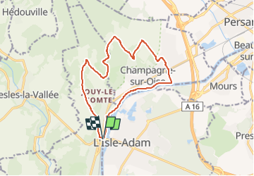

Length
13.6 km

Max alt
118 m

Uphill gradient
219 m
Km-Effort
16.5 km

Min alt
20 m

Downhill gradient
215 m
Boucle
Yes
Creation date :
2020-12-12 14:51:47.177
Updated on :
2023-01-11 11:01:19.072
3h34
Difficulty : Difficult

FREE GPS app for hiking
 SityTrail
IGN / Geographical institutes
SityTrail Plus
The world is yours!
About
Trail Walking of 13.6 km to be discovered at Ile-de-France, Val-d'Oise, Parmain. This trail is proposed by philberard95.
Positioning
Country:
France
Region :
Ile-de-France
Department/Province :
Val-d'Oise
Municipality :
Parmain
Location:
Unknown
Start:(Dec)
Start:(UTM)
442322 ; 5440396 (31U) N.
Comments