


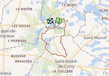
Monthieux-11km-78m

ThierryJ01
User

Length
10.9 km

Max alt
309 m

Uphill gradient
76 m
Km-Effort
11.9 km

Min alt
284 m

Downhill gradient
76 m
Boucle
Yes
Creation date :
2020-12-12 17:25:51.983
Updated on :
2020-12-12 17:40:18.389
2h39
Difficulty : Medium

FREE GPS app for hiking
 SityTrail
IGN / Geographical institutes
SityTrail Plus
The world is yours!
About
Trail Walking of 10.9 km to be discovered at Auvergne-Rhône-Alpes, Ain, Monthieux. This trail is proposed by ThierryJ01.
Description
Départ de la place de l'église de Monthieux
Positioning
Country:
France
Region :
Auvergne-Rhône-Alpes
Department/Province :
Ain
Municipality :
Monthieux
Location:
Unknown
Start:(Dec)
Start:(UTM)
650334 ; 5091038 (31T) N.
Comments
Balade sympathique qui permet de découvrir des étangs de la Dombes. sans difficulté.