


repvttuchaud

brandy
User
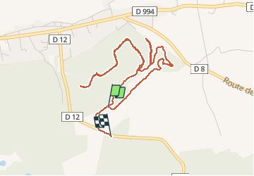

Length
5.6 km

Max alt
145 m

Uphill gradient
99 m
Km-Effort
6.9 km

Min alt
76 m

Downhill gradient
103 m
Boucle
No
Creation date :
2020-12-09 14:33:02.87
Updated on :
2020-12-12 22:11:06.127
1h20
Difficulty : Very easy

FREE GPS app for hiking
 SityTrail
IGN / Geographical institutes
SityTrail Plus
The world is yours!
About
Trail Walking of 5.6 km to be discovered at Provence-Alpes-Côte d'Azur, Vaucluse, Bollène. This trail is proposed by brandy.
Positioning
Country:
France
Region :
Provence-Alpes-Côte d'Azur
Department/Province :
Vaucluse
Municipality :
Bollène
Location:
Unknown
Start:(Dec)
Start:(UTM)
642072 ; 4903573 (31T) N.
Comments