


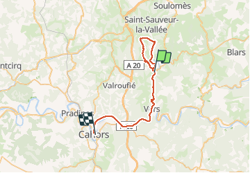
Au dessus vallée du Vers 18 Km

fxhedon
User

Length
39 km

Max alt
408 m

Uphill gradient
670 m
Km-Effort
48 km

Min alt
119 m

Downhill gradient
711 m
Boucle
No
Creation date :
2020-12-12 11:01:20.0
Updated on :
2020-12-13 08:25:53.557
4h00
Difficulty : Unknown

FREE GPS app for hiking
 SityTrail
IGN / Geographical institutes
SityTrail Plus
The world is yours!
About
Trail Walking of 39 km to be discovered at Occitania, Lot, Cras. This trail is proposed by fxhedon.
Description
Belle randonnée sur le causse et la vallée du Vers
Positioning
Country:
France
Region :
Occitania
Department/Province :
Lot
Municipality :
Cras
Location:
Unknown
Start:(Dec)
Start:(UTM)
385342 ; 4932627 (31T) N.
Comments