


Tournefort - col de la Madone

franquen
User
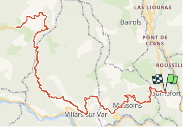

Length
43 km

Max alt
1169 m

Uphill gradient
1532 m
Km-Effort
63 km

Min alt
375 m

Downhill gradient
1533 m
Boucle
Yes
Creation date :
2020-12-13 09:45:43.663
Updated on :
2020-12-13 16:41:30.125
3h46
Difficulty : Easy

FREE GPS app for hiking
 SityTrail
IGN / Geographical institutes
SityTrail Plus
The world is yours!
About
Trail Mountain bike of 43 km to be discovered at Provence-Alpes-Côte d'Azur, Maritime Alps, Tournefort. This trail is proposed by franquen.
Description
bel itineraire sur route avec beaux villages. un peu trop foid et gelé en decembre
Positioning
Country:
France
Region :
Provence-Alpes-Côte d'Azur
Department/Province :
Maritime Alps
Municipality :
Tournefort
Location:
Unknown
Start:(Dec)
Start:(UTM)
351626 ; 4867782 (32T) N.
Comments