


Randonnée aux AVINS

tatous
User
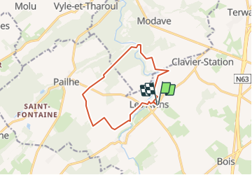

Length
10.4 km

Max alt
291 m

Uphill gradient
210 m
Km-Effort
13.2 km

Min alt
199 m

Downhill gradient
210 m
Boucle
Yes
Creation date :
2020-12-13 15:09:56.638
Updated on :
2021-08-27 14:42:47.033
2h50
Difficulty : Difficult

FREE GPS app for hiking
 SityTrail
IGN / Geographical institutes
SityTrail Plus
The world is yours!
About
Trail Walking of 10.4 km to be discovered at Wallonia, Liège, Clavier. This trail is proposed by tatous.
Positioning
Country:
Belgium
Region :
Wallonia
Department/Province :
Liège
Municipality :
Clavier
Location:
Les Avins
Start:(Dec)
Start:(UTM)
663681 ; 5587349 (31U) N.
Comments