


RONVRAI20 14:04:29

UDGI54
User
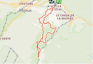

Length
9 km

Max alt
1600 m

Uphill gradient
395 m
Km-Effort
14.3 km

Min alt
1317 m

Downhill gradient
395 m
Boucle
Yes
Creation date :
2020-12-13 18:08:58.443
Updated on :
2020-12-13 18:09:44.018

FREE GPS app for hiking
 SityTrail
IGN / Geographical institutes
SityTrail Plus
The world is yours!
About
Trail of 9 km to be discovered at Auvergne-Rhône-Alpes, Ain, Gex. This trail is proposed by UDGI54.
Positioning
Country:
France
Region :
Auvergne-Rhône-Alpes
Department/Province :
Ain
Municipality :
Gex
Location:
Unknown
Start:(Dec)
Start:(UTM)
270478 ; 5139243 (32T) N.
Comments