


MONT FIER

UDGI54
User
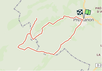

Length
10.1 km

Max alt
1291 m

Uphill gradient
322 m
Km-Effort
14.4 km

Min alt
1085 m

Downhill gradient
322 m
Boucle
Yes
Creation date :
2020-12-13 18:16:07.523
Updated on :
2020-12-13 18:16:07.523

FREE GPS app for hiking
 SityTrail
IGN / Geographical institutes
SityTrail Plus
The world is yours!
About
Trail of 10.1 km to be discovered at Bourgogne-Franche-Comté, Jura. This trail is proposed by UDGI54.
Positioning
Country:
France
Region :
Bourgogne-Franche-Comté
Department/Province :
Jura
Municipality :
PREMANON
Location:
Unknown
Start:(Dec)
Start:(UTM)
272006 ; 5149683 (32T) N.
Comments