


2020-12-13_21h05m00_Géronsart ST Martin Géronsart 2020-12-05 __20201205_1337

sarriette
User
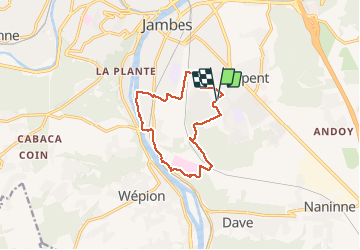

Length
10.3 km

Max alt
175 m

Uphill gradient
166 m
Km-Effort
12.5 km

Min alt
76 m

Downhill gradient
166 m
Boucle
Yes
Creation date :
2020-12-13 20:05:02.072
Updated on :
2020-12-13 20:05:05.713

FREE GPS app for hiking
 SityTrail
IGN / Geographical institutes
SityTrail Plus
The world is yours!
About
Trail of 10.3 km to be discovered at Wallonia, Namur, Namur. This trail is proposed by sarriette.
Positioning
Country:
Belgium
Region :
Wallonia
Department/Province :
Namur
Municipality :
Namur
Location:
Jambes
Start:(Dec)
Start:(UTM)
634185 ; 5589493 (31U) N.
Comments