


Rochehaut les échelles

Beranger Guillaume
User
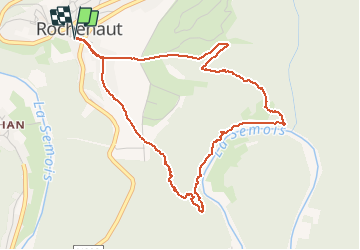

Length
4.7 km

Max alt
379 m

Uphill gradient
204 m
Km-Effort
7.5 km

Min alt
207 m

Downhill gradient
204 m
Boucle
Yes
Creation date :
2020-12-14 10:00:09.566
Updated on :
2020-12-14 11:24:57.877
1h24
Difficulty : Very easy

FREE GPS app for hiking
 SityTrail
IGN / Geographical institutes
SityTrail Plus
The world is yours!
About
Trail Walking of 4.7 km to be discovered at Wallonia, Luxembourg, Bouillon. This trail is proposed by Beranger Guillaume.
Positioning
Country:
Belgium
Region :
Wallonia
Department/Province :
Luxembourg
Municipality :
Bouillon
Location:
Rochehaut
Start:(Dec)
Start:(UTM)
644289 ; 5522759 (31U) N.
Comments
Deze tocht staat omschreven als "zeer gevaarlijk" route 43. wij zijn met ons gezelschap in de problemen gekomen. ik hoop dat de omschrijving een fout is en veranderd wordt, zo niet hebben we met een ideoot te maken. zeer moeilijk.