


Chagny circuit de l'ermitage page 107

grasgilbert
User
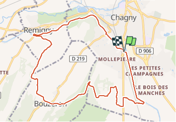

Length
11.7 km

Max alt
342 m

Uphill gradient
211 m
Km-Effort
14.5 km

Min alt
217 m

Downhill gradient
208 m
Boucle
Yes
Creation date :
2020-12-17 12:21:42.762
Updated on :
2021-08-05 15:43:18.415
3h02
Difficulty : Easy

FREE GPS app for hiking
 SityTrail
IGN / Geographical institutes
SityTrail Plus
The world is yours!
About
Trail Walking of 11.7 km to be discovered at Bourgogne-Franche-Comté, Saône-et-Loire, Chagny. This trail is proposed by grasgilbert.
Positioning
Country:
France
Region :
Bourgogne-Franche-Comté
Department/Province :
Saône-et-Loire
Municipality :
Chagny
Location:
Unknown
Start:(Dec)
Start:(UTM)
633484 ; 5195788 (31T) N.
Comments
b
très bien.