


plateau arselle

maupassant38
User
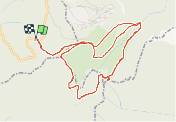

Length
9.8 km

Max alt
1657 m

Uphill gradient
184 m
Km-Effort
12.2 km

Min alt
1591 m

Downhill gradient
185 m
Boucle
Yes
Creation date :
2020-12-18 11:46:17.089
Updated on :
2020-12-18 15:03:30.173
1h09
Difficulty : Easy

FREE GPS app for hiking
 SityTrail
IGN / Geographical institutes
SityTrail Plus
The world is yours!
About
Trail Cross-country skiing of 9.8 km to be discovered at Auvergne-Rhône-Alpes, Isère, Vaulnaveys-le-Haut. This trail is proposed by maupassant38.
Positioning
Country:
France
Region :
Auvergne-Rhône-Alpes
Department/Province :
Isère
Municipality :
Vaulnaveys-le-Haut
Location:
Unknown
Start:(Dec)
Start:(UTM)
725729 ; 4997978 (31T) N.
Comments