


BoucleGTFPC

mvrydagh
User
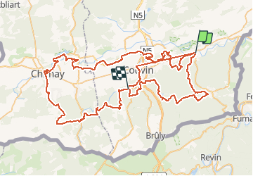

Length
113 km

Max alt
380 m

Uphill gradient
2384 m
Km-Effort
144 km

Min alt
140 m

Downhill gradient
2314 m
Boucle
No
Creation date :
2020-12-18 16:05:13.297
Updated on :
2020-12-18 16:05:13.297

FREE GPS app for hiking
 SityTrail
IGN / Geographical institutes
SityTrail Plus
The world is yours!
About
Trail of 113 km to be discovered at Wallonia, Namur, Viroinval. This trail is proposed by mvrydagh.
Positioning
Country:
Belgium
Region :
Wallonia
Department/Province :
Namur
Municipality :
Viroinval
Location:
Olloy-sur-Viroin
Start:(Dec)
Start:(UTM)
614986 ; 5547931 (31U) N.
Comments