


TURET 03 11:51:01

UDGI54
User
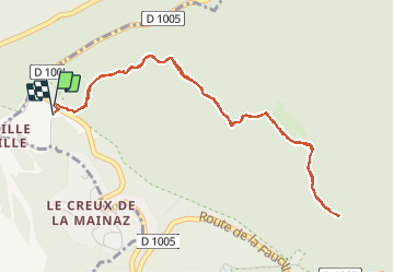

Length
5.5 km

Max alt
1416 m

Uphill gradient
172 m
Km-Effort
7.8 km

Min alt
1322 m

Downhill gradient
179 m
Boucle
Yes
Creation date :
2020-12-19 12:37:09.654
Updated on :
2020-12-19 12:37:54.563

FREE GPS app for hiking
 SityTrail
IGN / Geographical institutes
SityTrail Plus
The world is yours!
About
Trail of 5.5 km to be discovered at Auvergne-Rhône-Alpes, Ain, Gex. This trail is proposed by UDGI54.
Positioning
Country:
France
Region :
Auvergne-Rhône-Alpes
Department/Province :
Ain
Municipality :
Gex
Location:
Unknown
Start:(Dec)
Start:(UTM)
270777 ; 5139362 (32T) N.
Comments