


Lauzerte Bouloc

Glurps
User
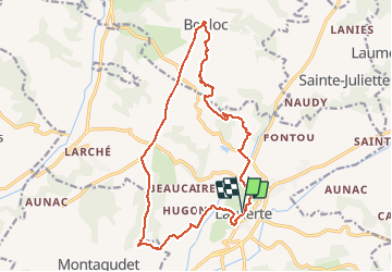

Length
18.1 km

Max alt
257 m

Uphill gradient
391 m
Km-Effort
23 km

Min alt
101 m

Downhill gradient
390 m
Boucle
Yes
Creation date :
2020-12-20 11:01:20.0
Updated on :
2020-12-20 15:39:51.676
4h10
Difficulty : Unknown

FREE GPS app for hiking
 SityTrail
IGN / Geographical institutes
SityTrail Plus
The world is yours!
About
Trail Walking of 18.1 km to be discovered at Occitania, Tarn-et-Garonne, Lauzerte. This trail is proposed by Glurps.
Description
Boucle
Positioning
Country:
France
Region :
Occitania
Department/Province :
Tarn-et-Garonne
Municipality :
Lauzerte
Location:
Unknown
Start:(Dec)
Start:(UTM)
351322 ; 4902095 (31T) N.
Comments