


fagette

Spinnaker
User
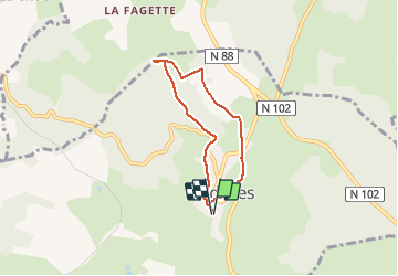

Length
5.6 km

Max alt
1253 m

Uphill gradient
150 m
Km-Effort
7.6 km

Min alt
1125 m

Downhill gradient
150 m
Boucle
Yes
Creation date :
2020-12-20 14:33:30.902
Updated on :
2020-12-20 15:53:44.737
1h15
Difficulty : Very easy

FREE GPS app for hiking
 SityTrail
IGN / Geographical institutes
SityTrail Plus
The world is yours!
About
Trail Walking of 5.6 km to be discovered at Auvergne-Rhône-Alpes, Haute-Loire, Pradelles. This trail is proposed by Spinnaker.
Positioning
Country:
France
Region :
Auvergne-Rhône-Alpes
Department/Province :
Haute-Loire
Municipality :
Pradelles
Location:
Unknown
Start:(Dec)
Start:(UTM)
569853 ; 4957552 (31T) N.
Comments