


agnel

m@nu
User
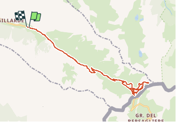

Length
24 km

Max alt
2900 m

Uphill gradient
1141 m
Km-Effort
40 km

Min alt
2023 m

Downhill gradient
1146 m
Boucle
Yes
Creation date :
2020-12-21 11:05:16.746
Updated on :
2020-12-21 15:45:44.56
4h39
Difficulty : Very easy

FREE GPS app for hiking
 SityTrail
IGN / Geographical institutes
SityTrail Plus
The world is yours!
About
Trail Touring skiing of 24 km to be discovered at Provence-Alpes-Côte d'Azur, Hautes-Alpes, Molines-en-Queyras. This trail is proposed by m@nu.
Positioning
Country:
France
Region :
Provence-Alpes-Côte d'Azur
Department/Province :
Hautes-Alpes
Municipality :
Molines-en-Queyras
Location:
Unknown
Start:(Dec)
Start:(UTM)
334088 ; 4953833 (32T) N.
Comments