


Tour Source du Lamalou - Commune du Rouet

DiagMan
User
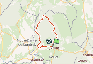

Length
11.5 km

Max alt
318 m

Uphill gradient
164 m
Km-Effort
13.7 km

Min alt
185 m

Downhill gradient
165 m
Boucle
Yes
Creation date :
2020-12-25 11:23:48.752
Updated on :
2020-12-25 11:24:54.6
2h59
Difficulty : Difficult

FREE GPS app for hiking
 SityTrail
IGN / Geographical institutes
SityTrail Plus
The world is yours!
About
Trail Walking of 11.5 km to be discovered at Occitania, Hérault, Rouet. This trail is proposed by DiagMan.
Positioning
Country:
France
Region :
Occitania
Department/Province :
Hérault
Municipality :
Rouet
Location:
Unknown
Start:(Dec)
Start:(UTM)
565306 ; 4852384 (31T) N.
Comments