


mont bisane

phil21
User
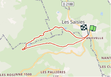

Length
7.2 km

Max alt
1935 m

Uphill gradient
364 m
Km-Effort
12.1 km

Min alt
1573 m

Downhill gradient
361 m
Boucle
Yes
Creation date :
2020-12-28 10:13:08.024
Updated on :
2020-12-28 13:04:28.824
2h49
Difficulty : Very easy

FREE GPS app for hiking
 SityTrail
IGN / Geographical institutes
SityTrail Plus
The world is yours!
About
Trail Touring skiing of 7.2 km to be discovered at Auvergne-Rhône-Alpes, Savoy, Hauteluce. This trail is proposed by phil21.
Positioning
Country:
France
Region :
Auvergne-Rhône-Alpes
Department/Province :
Savoy
Municipality :
Hauteluce
Location:
Unknown
Start:(Dec)
Start:(UTM)
309024 ; 5069565 (32T) N.
Comments