


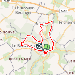
clères 12 kms
© OpenStreetMap contributors


3h17
Difficulty : Medium


Length
12.3 km
Max alt
175 m
Uphill gradient
209 m
Km-Effort
15.1 km
Min alt
92 m
Downhill gradient
211 m
Boucle
Yes
Creation date :
2014-12-10 00:00:00.0
Updated on :
2014-12-10 00:00:00.0
3h17
Difficulty : Medium
FREE GPS app for hiking
 SityTrail
IGN / Geographical institutes
SityTrail Plus
The world is yours!
About
Trail Walking of 12.3 km to be discovered at Normandy, Seine-Maritime, Clères. This trail is proposed by nicole.reine@wanadoo.fr.
Description
départ gare
Positioning
Country:
France
Region :
Normandy
Department/Province :
Seine-Maritime
Municipality :
Clères
Location:
Unknown
Start:(Dec)
Start:(UTM)
363130 ; 5495746 (31U) N.
Comments