


orvey

jojo02
User
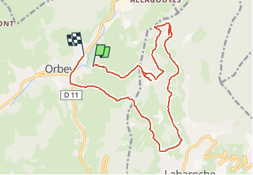

Length
10 km

Max alt
738 m

Uphill gradient
369 m
Km-Effort
15.1 km

Min alt
452 m

Downhill gradient
411 m
Boucle
No
Creation date :
2020-12-29 15:30:34.616
Updated on :
2020-12-29 20:42:46.454
1h46
Difficulty : Easy

FREE GPS app for hiking
 SityTrail
IGN / Geographical institutes
SityTrail Plus
The world is yours!
About
Trail Trail of 10 km to be discovered at Grand Est, Haut-Rhin, Orbey. This trail is proposed by jojo02.
Positioning
Country:
France
Region :
Grand Est
Department/Province :
Haut-Rhin
Municipality :
Orbey
Location:
Unknown
Start:(Dec)
Start:(UTM)
363867 ; 5332094 (32U) N.
Comments