


col de very

phil21
User
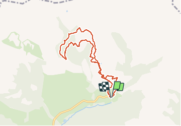

Length
8.3 km

Max alt
1784 m

Uphill gradient
600 m
Km-Effort
16.3 km

Min alt
1227 m

Downhill gradient
601 m
Boucle
Yes
Creation date :
2020-12-30 08:57:28.987
Updated on :
2020-12-30 13:36:17.289
4h34
Difficulty : Medium

FREE GPS app for hiking
 SityTrail
IGN / Geographical institutes
SityTrail Plus
The world is yours!
About
Trail Touring skiing of 8.3 km to be discovered at Auvergne-Rhône-Alpes, Savoy, Hauteluce. This trail is proposed by phil21.
Positioning
Country:
France
Region :
Auvergne-Rhône-Alpes
Department/Province :
Savoy
Municipality :
Hauteluce
Location:
Unknown
Start:(Dec)
Start:(UTM)
316518 ; 5071526 (32T) N.
Comments