


Gouvy . Limerlé . Cherapont . Gouvy

stef789
User GUIDE
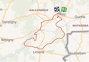

Length
15.6 km

Max alt
496 m

Uphill gradient
308 m
Km-Effort
19.7 km

Min alt
410 m

Downhill gradient
307 m
Boucle
Yes
Creation date :
2020-12-30 10:29:59.828
Updated on :
2020-12-30 17:21:31.408
4h40
Difficulty : Very easy

FREE GPS app for hiking
 SityTrail
IGN / Geographical institutes
SityTrail Plus
The world is yours!
About
Trail Walking of 15.6 km to be discovered at Wallonia, Luxembourg, Gouvy. This trail is proposed by stef789.
Photos


Positioning
Country:
Belgium
Region :
Wallonia
Department/Province :
Luxembourg
Municipality :
Gouvy
Location:
Limerlé
Start:(Dec)
Start:(UTM)
710877 ; 5563905 (31U) N.
Comments