


Croix feu

luccho
User
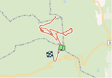

Length
9.9 km

Max alt
1612 m

Uphill gradient
177 m
Km-Effort
12.4 km

Min alt
1464 m

Downhill gradient
200 m
Boucle
No
Creation date :
2020-12-31 11:48:16.0
Updated on :
2020-12-31 14:25:31.776
2h36
Difficulty : Easy

FREE GPS app for hiking
 SityTrail
IGN / Geographical institutes
SityTrail Plus
The world is yours!
About
Trail Cross-country skiing of 9.9 km to be discovered at Auvergne-Rhône-Alpes, Upper Savoy, Manigod. This trail is proposed by luccho.
Positioning
Country:
France
Region :
Auvergne-Rhône-Alpes
Department/Province :
Upper Savoy
Municipality :
Manigod
Location:
Unknown
Start:(Dec)
Start:(UTM)
298610 ; 5083933 (32T) N.
Comments