


reco Verrières

DaVinci
User
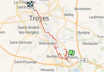

Length
27 km

Max alt
119 m

Uphill gradient
145 m
Km-Effort
29 km

Min alt
100 m

Downhill gradient
158 m
Boucle
No
Creation date :
2020-12-31 13:18:42.6
Updated on :
2020-12-31 17:36:10.227
4h15
Difficulty : Very easy

FREE GPS app for hiking
 SityTrail
IGN / Geographical institutes
SityTrail Plus
The world is yours!
About
Trail Walking of 27 km to be discovered at Grand Est, Aube, Verrières. This trail is proposed by DaVinci.
Positioning
Country:
France
Region :
Grand Est
Department/Province :
Aube
Municipality :
Verrières
Location:
Unknown
Start:(Dec)
Start:(UTM)
584939 ; 5342664 (31U) N.
Comments