


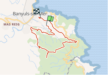
Seris, tour Pages, Col de la Ceu, puig Jouan, route de Cerbère et retour

BernardPONS
User

Length
9.1 km

Max alt
291 m

Uphill gradient
303 m
Km-Effort
13.2 km

Min alt
39 m

Downhill gradient
304 m
Boucle
No
Creation date :
2021-01-01 09:53:41.416
Updated on :
2021-01-01 13:44:17.837
2h37
Difficulty : Easy

FREE GPS app for hiking
 SityTrail
IGN / Geographical institutes
SityTrail Plus
The world is yours!
About
Trail Walking of 9.1 km to be discovered at Occitania, Pyrénées-Orientales, Banyuls-sur-Mer. This trail is proposed by BernardPONS.
Positioning
Country:
France
Region :
Occitania
Department/Province :
Pyrénées-Orientales
Municipality :
Banyuls-sur-Mer
Location:
Unknown
Start:(Dec)
Start:(UTM)
511278 ; 4702452 (31T) N.
Comments